
3D Laser Scanning in Devon: Point-Cloud Capture for Architects and Engineers
TruGrid Surveys provides survey-grade 3D laser scanning across Devon as well as Cornwall. We are based in Truro and regularly travel into Devon for point-cloud capture, measured building surveys and topographical work. If you need a building, structure or site recorded accurately and delivered as a registered point cloud, this is what we do.
Where we work in Devon
We cover the whole county, including Plymouth, Exeter, Torbay, Newton Abbot, Totnes, Tavistock, Okehampton, Tiverton, Exmouth, Barnstaple and Bideford. That includes properties within Dartmoor and Exmoor National Parks, where planning officers often ask for accurate as-existing drawings of historic buildings.
What point-cloud capture gives you
A laser scanner records millions of measured points across every visible surface. Once the scans are registered, you have a complete 3D record of the building or site that can be measured, sectioned and drawn in the office.
Complete capture in a single visit, so return trips are rare
Complex geometry recorded exactly as built: roof structures, vaulted ceilings, uneven walls and plant
Scans controlled by total station, so inside, outside and every floor share one coordinate system
Data tied to OS National Grid and Ordnance Datum where the project requires it
Equipment
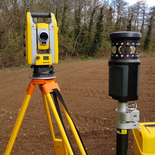
We scan with a Trimble X9 3D laser scanner, controlled by a Trimble robotic total station and GNSS. Registration is carried out and checked in Trimble RealWorks before any drawing work starts, and registration reports can be supplied with the data.
Point-cloud formats we deliver
E57: the open, vendor-neutral format that most point-cloud software can read
RCP and RCS: Autodesk ReCap format for Revit, AutoCAD and Civil 3D users
LAS or LAZ: common in GIS and terrain workflows
We agree the format with your architect or engineer before issue. See our guide to choosing a point-cloud format for more detail.
Typical Devon projects
As-existing drawings for extensions, barn conversions and refurbishments
Listed buildings and properties in conservation areas
Commercial, industrial and hospitality buildings being reconfigured
Bridges, retaining walls and other structures for engineers
Roof surveys where access is difficult, including true sloping roof areas
Drawings from the scan
Most clients want drawings rather than raw data. We extract floor plans, elevations, sections and site plans from the registered cloud and issue them as layered DWG and scaled PDF, with the point cloud supplied alongside if needed.
Get a quotation
Send the property address, what needs scanning and the deliverables your design team wants. We usually reply with a fixed quotation within one working day. Read more about our 3D laser scanning service or contact us.
Comments