
3D Laser Scanning & Point Cloud Surveys in Cornwall & Devon
- Aaron Bennett
- Dec 22, 2025
- 5 min read
Updated: Mar 28

TruGrid Surveys Ltd provides professional 3D laser scanning and point cloud survey services across Cornwall and Devon, delivering millimetre-accurate data for construction, architecture, and engineering projects. This guide explains how the technology works, who it benefits, and what to expect when commissioning a scan with our team.
Understanding 3D Point Cloud Technology
What Is a 3D Point Cloud?
A 3D point cloud is a dense collection of data points, each with a precise X, Y, and Z coordinate, representing the physical surfaces of structures, terrain, and objects in three-dimensional space. Using high-speed time-of-flight laser technology - such as the Trimble X9, which captures up to one million points per second - a scanner builds a complete digital replica of any surveyed environment in a single session. Each scan station typically takes under six minutes, and multiple stations are registered together to produce a seamless, comprehensive dataset. The resulting point cloud forms the foundation for CAD drawings, BIM models, and architectural or engineering documentation.
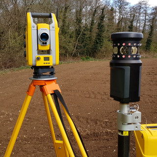
How Does TruGrid Surveys Ltd Capture Point Cloud Data?
TruGrid Surveys uses the Trimble X9 3D laser scanner - a survey-grade instrument with a 2mm range accuracy and a scanning range of up to 150 metres. The scanner is fully self-levelling with auto-calibration built in, which guarantees accuracy is maintained on every scan without the need for manual targets or user interaction. On site, the scanner is positioned at multiple stations to ensure complete coverage, with each station scan completing in as little as one to six minutes depending on density settings. The resulting point cloud data is registered, processed, and delivered in E57, RCP, and DWG formats, compatible with AutoCAD, Revit, and Trimble Business Center.
Industries We Serve Across Cornwall and Devon
TruGrid Surveys Ltd provides 3D laser scanning and point cloud survey services to a broad range of professional clients across Cornwall, Devon, and the South West. Our work supports the following sectors:
Architecture and Building Design: Architects working across Cornwall and Devon use our point cloud data to create accurate existing conditions models for renovation, extension, and new-build projects. Our data integrates directly with Revit, AutoCAD, and other BIM platforms.
Construction and Civil Engineering: Contractors and civil engineers rely on our 3D scanning services for site progress monitoring, clash detection, and as-built verification, ensuring that construction aligns precisely with design intent.
Heritage and Historic Building Recording: Cornwall and Devon are home to an exceptional wealth of listed buildings, historic properties, and ancient structures. TruGrid Surveys Ltd provides detailed heritage recording surveys that capture complex architectural features with millimetre precision, supporting conservation and planning applications.
Property Development and Land Management: Developers and landowners across the South West commission our services for accurate site appraisals, boundary verification, and topographical data capture as part of their planning and development processes.
The Benefits of 3D Laser Scanning for Projects in Cornwall & Devon
Millimetre Accuracy for Confident Decision-Making
The Trimble X9 delivers a verified range accuracy of 2mm, with 3D point accuracy of 2.3mm at 10 metres and 4.8mm at 40 metres. This survey-grade precision significantly reduces the risk of design errors that arise from manual measurement or outdated drawings. For architects and engineers working on complex or sensitive projects throughout Cornwall and Devon, this level of accuracy provides a reliable foundation for design, planning, and construction - and eliminates the need for costly repeat site visits.
Improved Project Efficiency and Reduced On-Site Time
3D laser scanning substantially reduces the time required on-site compared to traditional manual survey methods. A single scanning session at a site in Cornwall or Devon can capture vast amounts of spatial data within hours, enabling our team to process and deliver survey outputs promptly. This efficiency is particularly valuable for projects on occupied or operational sites, where minimising disruption is a priority.
Seamless BIM Integration and Data Delivery
TruGrid Surveys Ltd delivers point cloud data in formats that integrate directly with major industry software. Our outputs are compatible with Autodesk Revit, AutoCAD, Trimble Business Center, and other BIM and CAD platforms, enabling architects, engineers, and contractors across Cornwall and the South West to incorporate survey data directly into their workflows without the need for manual re-drawing or data conversion.
Our Work Across Cornwall and Devon
TruGrid Surveys Ltd has undertaken a wide variety of 3D laser scanning projects across Cornwall and the wider South West. The following examples illustrate the types of commissions we regularly undertake.
Historic Building Recording in Truro, Cornwall
TruGrid Surveys Ltd was commissioned to carry out a full measured building survey and 3D laser scan of a Grade II listed property in Truro, Cornwall, for use in connection with a proposed conversion and heritage consent application. The Trimble X9 scanner was used to capture the full internal and external fabric of the building, including ornate plasterwork, original roof trusses, and historic stonework. The resulting point cloud was used to produce a complete set of as-existing floor plans, elevations, and sections in CAD format, providing the client's architect with the detail required to progress the application with confidence.
Barn Conversion Survey, Devon
An architect in Devon engaged TruGrid Surveys Ltd to provide a full measured building survey of a large Cornish stone barn earmarked for residential conversion. The scan captured all internal spaces, structural elements, and external elevations in a single site visit, allowing the architect to work from a verified and complete dataset. CAD drawings derived from the point cloud formed the basis of the planning application and enabled the design team to develop detailed proposals without the need for repeat site visits.
Commercial Development Survey, South West
A property developer required a comprehensive topographical survey and 3D laser scan of a former commercial site in the South West, to support a mixed-use residential development application. TruGrid Surveys Ltd conducted a full site survey incorporating topographic data capture and 3D scanning of the existing structures. The combined dataset was delivered to the developer's planning consultant and structural engineers, enabling a coordinated approach to the redevelopment proposals and supporting the submission of a detailed planning application to the local authority.
Commissioning a 3D Laser Scan: What to Consider
When planning to commission a 3D laser scan for your project in Cornwall or Devon, the following considerations will help ensure that you receive the most appropriate and cost-effective service:
Define your required deliverables: Establish clearly whether you require raw point cloud data, processed CAD drawings, BIM models, or a combination of these outputs. TruGrid Surveys Ltd will advise on the most suitable deliverables for your project at the outset.
Site access and logistics: For sites in more remote areas of Cornwall or Devon, site access, ground conditions, and the extent of the area to be scanned will all influence the survey methodology and programme. We will undertake a site assessment prior to mobilisation where required.
Data format compatibility: Confirm the software platforms used by your design team before commissioning a scan. TruGrid Surveys Ltd can deliver data in E57, RCP, DWG, and PDF formats, and will discuss compatibility requirements during the initial enquiry stage.
Budget and programme: Contact TruGrid Surveys Ltd to discuss your project requirements and receive a detailed, competitive quotation. We provide transparent pricing with no hidden costs and can advise on the most efficient survey approach to meet your budget and programme.
Conclusion
3D laser scanning has fundamentally changed what's possible in land surveying - delivering a speed, accuracy and level of detail that traditional methods simply can't match. Whether you're an architect needing a verified existing conditions model, a contractor requiring as-built confirmation, or a developer planning a complex site, point cloud data from TruGrid Surveys gives you a reliable foundation to work from.
To discuss your project or request a quotation, call us on 07977 816012 or email info@trugrid.co.uk. Most quotes are turned around within 1-2 working days.
Comments