
Understanding Measured Building Surveys for Accurate Planning
- Aaron Bennett
- Dec 22, 2025
- 7 min read
Updated: Mar 28
A measured building survey gives you accurate, verified data about a building’s dimensions, layout and features - everything an architect, engineer or contractor needs to design with confidence. At TruGrid Surveys Ltd, we carry out measured building surveys across Cornwall and Devon, delivering detailed floor plans, elevations, sections and 3D data that slot directly into your design workflow.

What is a Measured Building Survey?
A measured building survey is a detailed, accurate record of a building's existing dimensions, layout, and physical features - as it actually exists on site rather than as originally designed. It captures wall positions, floor and ceiling levels, openings, structural elements, and services to produce drawings that reflect true site conditions. Surveys are undertaken in accordance with the RICS Measured Surveys of Land, Buildings and Utilities guidance to ensure accuracy and consistency across all deliverables.
Key Components of a Measured Building Survey
Site Measurements: Internal and external dimensions are captured using calibrated laser measuring devices, Trimble robotic total stations and hand measurements where required. This covers room sizes, wall thicknesses, ceiling heights, structural openings and external façade dimensions.
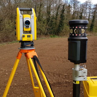
3D Laser Scanning: Where complexity or speed demands it, TruGrid deploys the Trimble X9 laser scanner to capture millions of data points in minutes. The resulting point cloud provides a precise, photorealistic record of every surface - ideal for listed buildings, complex rooflines and multi-storey structures where traditional measuring would be time-consuming or error-prone.
Photographic Documentation: Systematic photography records the condition of all areas, highlighting any defects, unusual features or constraints that will affect the design. Photos are cross-referenced with the measured drawings so architects and engineers have a complete visual and dimensional record.
CAD Drawing Production: Field data is processed in CAD software to produce scaled 2D drawings - typically floor plans, elevations and sections - and where required, 3D models or point cloud outputs. All drawings are delivered in DWG, PDF and other formats specified by your design team, ready for use in planning applications, RIBA-stage design, or building regulations submissions.
Why Are Measured Building Surveys Important?
Whether you're a homeowner planning an extension, an architect designing a refurbishment, or a developer assessing a conversion, the case for commissioning a measured survey before design begins is straightforward:
Accuracy you can rely on: Your design is only as good as the data it's based on. Measured building surveys eliminate guesswork and reduce the risk of costly design revisions caused by incorrect or assumed dimensions.
Early identification of constraints: Structural irregularities, changes in floor level, non-plumb walls and hidden features are discovered during the survey - not halfway through construction when they're far more expensive to resolve.
Planning application support: Accurate floor plans and elevations are commonly required by Local Planning Authorities for change of use, conversion and extension applications, particularly in Cornwall where many projects involve listed buildings or properties in conservation areas.
Better collaboration across the project team: When architects, structural engineers and contractors are all working from the same verified survey drawings, fewer assumptions are made, communication improves, and the risk of clashes between disciplines is significantly reduced.
The Process of Conducting a Measured Building Survey
Conducting a measured building survey involves several steps:
1. Initial Consultation
Before the survey begins, a consultation is held with the client to understand their specific needs and objectives. This helps in determining the scope of the survey.
2. Site Visit
Our surveyor visits site to carry out a comprehensive measured inspection, working methodically through every space. All internal and external dimensions are captured, along with ceiling heights, floor levels, structural features, openings and services. Photographic documentation is completed at the same time.
3. Data Collection
Where the complexity or scale of a building warrants it, TruGrid deploys the Trimble X9 laser scanner to capture a dense point cloud of every surface. This is particularly effective in buildings with complex geometry, curved features, or where access with traditional instruments is restricted. For straightforward projects, calibrated hand instruments and laser measures are used alongside a Trimble total station to ensure accuracy throughout.
4. Data Processing
Field data and point cloud files are processed back in the office using specialist CAD and surveying software. Drawings are drafted to the agreed level of detail - typically RICS Level 2 or Level 3 - covering floor plans at each level, external elevations, cross-sections and, where required, roof plans. Outputs are checked for dimensional consistency before delivery.
5. Reporting
Completed drawings are issued digitally in your specified format - DWG, PDF, or both. We can also provide point cloud files (E57, RCP) where required for BIM or heritage workflows. Any queries on the drawings are dealt with promptly, and minor amendments are typically returned the same day.
Applications of Measured Building Surveys
TruGrid carries out measured building surveys for a wide range of clients and project types across Cornwall and Devon, including:
1. Renovation Projects
House extensions, loft conversions, and full property refurbishments all benefit from a measured survey before design work starts. Architects can progress from RIBA Stage 1 into detailed design using accurate existing drawings rather than assumptions or outdated plans.
2. Historical Preservation
Cornwall has a high density of listed buildings, conservation areas and historic farm buildings. Measured building surveys provide the accurate floor plans, elevations and section drawings that heritage consultants and conservation architects require when seeking Listed Building Consent or carrying out grant-funded restoration work.
3. Real Estate Development
Barn conversions, disused commercial buildings and permitted development projects all require existing building surveys at the feasibility stage. Accurate measured drawings help developers assess floor areas, structural constraints and planning viability before committing to further design fees.
4. Facility Management
Commercial and public sector clients - including schools, offices and healthcare facilities - use measured surveys as the baseline for planned maintenance programmes, space planning exercises and building upgrades. Having accurate, up-to-date floor plans saves time and cost when working with multiple contractors or consultants across a building portfolio.
Technology in Measured Building Surveys
The tools used on a measured building survey have evolved significantly over the past decade, improving both accuracy and efficiency. TruGrid uses a combination of traditional and advanced technology to suit the scale and complexity of each project:
1. Laser Scanning
The Trimble X9 is TruGrid's primary laser scanning instrument for complex measured building survey work. With a range accuracy of 2mm, point accuracy of 2.3mm at 10m and scanning speeds up to 1 million points per second, it captures every surface in a building with exceptional detail in just 1–6 minutes per scan position. The resulting point cloud can be used to extract floor plans, sections and elevations with sub-millimetre reference.
2. Drones
Where external façade surveys of tall or inaccessible buildings are required, drone photogrammetry can complement the ground-based measured survey by capturing elevations and roof details that would be difficult to access safely. However, for most internal measured building survey work, laser scanning and hand instruments remain the primary tools.
3. Building Information Modeling (BIM)
TruGrid delivers survey outputs in DWG and PDF formats that integrate directly with Autodesk Revit and other BIM-capable software. Point cloud files in E57 and RCP format can be used by design teams as the basis for Revit families and BIM models, particularly on more complex refurbishment and heritage projects where existing conditions need to be accurately represented in the BIM environment.
Challenges in Measured Building Surveys
Every measured building survey comes with practical challenges that experienced surveyors need to manage. Here are the most common ones and how TruGrid handles them:
1. Access Issues
Occupied buildings require careful coordination with occupants to minimise disruption and ensure all areas can be safely accessed. We agree an access schedule with the client in advance and, where possible, survey room by room to allow normal use to continue during the visit.
2. Complex Structures
Older buildings in particular - including many of Cornwall's historic farmhouses, terraces and converted industrial structures - feature non-standard wall thicknesses, irregular room shapes and significant structural movement. These buildings take longer to survey accurately, and it's precisely where the combination of laser scanning and traditional instrument work pays dividends.
3. Data Management
Point cloud files from a single project can run to several gigabytes. TruGrid uses structured file management and established naming conventions to keep all data organised, backed up and easily retrievable - both during processing and after delivery, should any revisions be required.
Best Practices for Conducting Measured Building Surveys
Whether you're commissioning your first measured building survey or you've worked with surveyors before, the following points will help the process go smoothly:
1. Plan Thoroughly
Brief your surveyor clearly on the scope of work. Let us know at the outset which floors need to be captured, whether you require internal, external or both, what drawing outputs you need (plans, elevations, sections) and the intended use - planning, design, heritage or BIM. The more detail we have upfront, the more accurately we can scope the survey and quote.
2. Use the Right Tools
Confirm in advance what format you and your architect or engineer need the drawings in. Most design teams work in DWG (AutoCAD or Revit-compatible), but PDF is also commonly requested for planning submissions. If you need point cloud data for BIM, specify E57 or RCP at the outset so the survey methodology can be planned accordingly.
3. Communicate with Stakeholders
Make sure all areas of the building that need to be surveyed will be accessible on the day. A locked room or a blocked-off basement can delay the survey or require a return visit, adding cost and time to the project. If tenants or occupants are involved, liaise with them in advance so the surveyor has uninterrupted access.
4. Document Everything
Once drawings are issued, review them carefully against your own knowledge of the building. If something looks wrong or you think an area has been missed, raise it promptly. TruGrid is happy to discuss any queries on the drawings and will address any genuine omissions or amendments quickly - usually on the same day they're raised.
Conclusion
A good measured building survey removes uncertainty from your project at the earliest stage. Whether you’re planning a renovation, designing an extension, converting a barn or restoring a listed building in Cornwall or Devon, having verified, accurate data means your design team can work with confidence - and avoids costly rework further down the line.
To commission a measured building survey in Cornwall or Devon, call TruGrid Surveys on 07977 816012 or email info@trugrid.co.uk. Quotes are typically returned within 1-2 working days.
Comments